Latest image in gallery

ACTION: C.2:
Restoration and regulation of natural water regime of sodic lakes
The aim of the action is achieveing an ecologically stable condition of sodic lakes and keeping it.

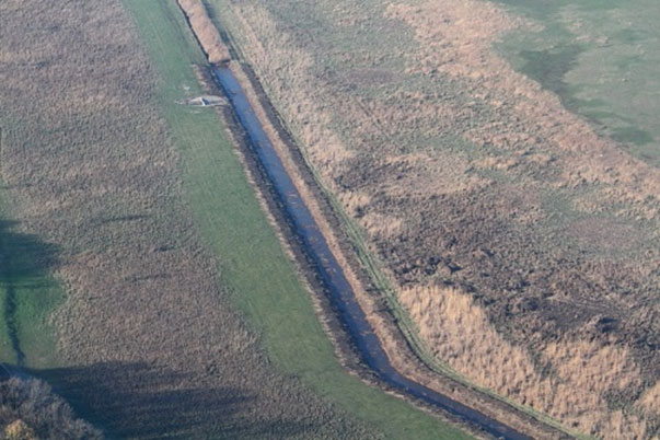
Photo: Zab-szék in Szabadszállás is one of those very rare sodic lakes with almost
untouched natural running (Photo: Zoltán Ecsedi).
In 2009: According to our plan, no activities have been implemented yet.
In 2010: According to our plans, no activities have been due yet.
In 2011: No activities have been done yet. The actions were due to start in 2010. The action is now expected to be implemented in the summer of 2012 due to the delay of the approval of the permitted plan. As soon as the final permit for the technical plan is given we will start the selection process to find the suitable contractor and the technical supervisor.
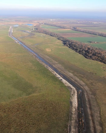
In 2012: By the end of June 2012 we had an approved permitted implementation plan by TIKÖFE and the field works of this action were finally started on the 20th of July in 2012. In map 1 there is a summary of the realized works in the Nagy-szik. One of the major works of the entire field work is to convert the unnatural deep channel of Magdolna-ér into an overflowing shallow watercourse. This was completed in 2012.

Picture: Machines working on the Magdolna-ér channel. The aim is to convert the channel into a shallow, more natural watercourse (Photo: János Oláh).

Picture: Machines working on the Magdolna-ér channel. The aim is to convert the channel into a shallow, more natural watercourse (Photo: János Oláh).
Picture: The Magdolna-ér after the rehabilitation in October 2012 (Photo: János Oláh).
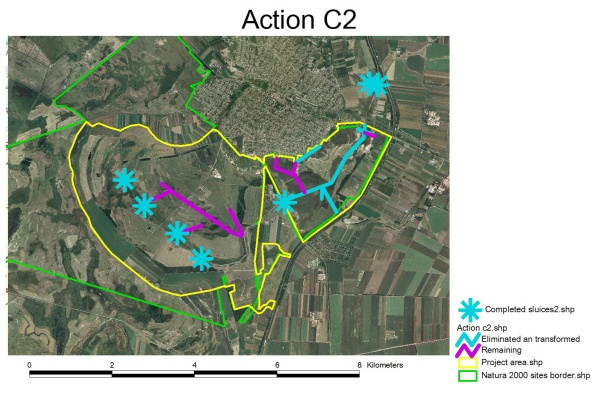
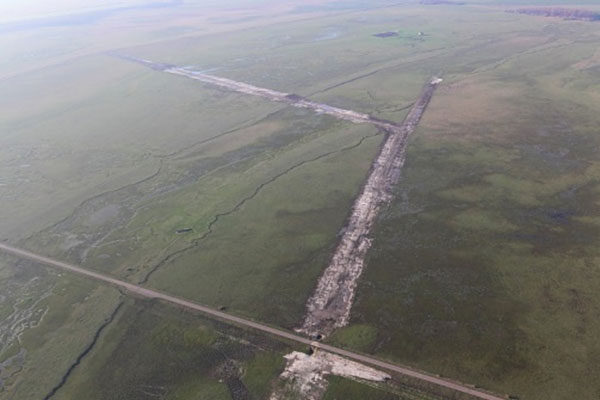
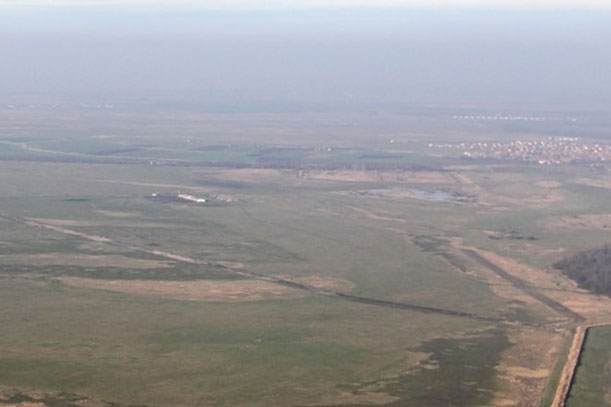
Map 1. Action C2 field works until 31st December 2012 (draining channel system to be eliminated).
2013: The plans and the intended target of the action has been 100% achieved, which are summarized in the tables and illustrated by pictures below.
Table: Field works of Action C.2
|
|
Built-in sluice and ogee-type weir | Elimination of embankment | Eliminated channel | Embank fortification with locally excavated material | Channel transformed into natural watercourse (Magdolna-ér) |
|
Permitted technical plan for Nagy-szik |
3 | 5,937km | 2,3 km | 0,850 km | 2,967 km |
|
Realized works until 31st December 2013 in the Nagy-szik |
3 | 5,937 km | 2,3 km | 0,850 km | 2,967 km |
|
Permitted technical plan for Magdolna-puszta |
4 |
0 |
4,147 km |
0,800 + 1,575 + 0,1 km |
0 |
|
Realized works until 31st December 2013 in the Magdolna-puszta |
4 | 0 | 4,147 km |
0,800
+ 1,575 + 0,1 km |
0 |

Map 1.: Action C.2 field works until 31st December 2013 (draining channel system to be eliminated)

Picture: Map 1-1: Sluice on ‘Virágoskúti csatorna’ at 5570 meter
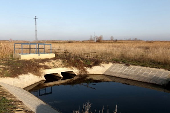
Picture: Map 1-2: Sluice on ‘Magdolna-ér’ at 12 800 meter
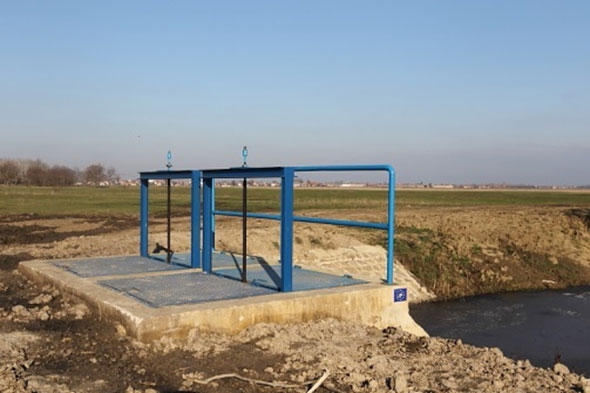
Picture: Map 1-3: Sluice on ‘Magdolna-ér’ at 8840 meter
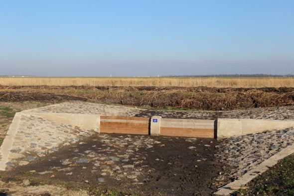
Picture: Map 1-4: Ogee-type weir on ‘Magdolna-ér’ at 5900 meter

Picture: Map 1-5: Ogee-type weir on ‘Magdolna-ér’ at 5070 meter

Picture: Map 1-6: Ogee-type weir on ‘Magdolna-ér’ at 3900 meter

Picture: Map 1-7: Ogee-type weir on ‘Magdolna-ér’ at 3100 meter

Picture: Map 1-8: Elimination of the embankment of ‘Magdolna-ér’ in Nagy-szik (before elimination)
Picture: Map 1-9: Elimination of the embankment of ‘Magdolna-ér’ in Nagy-szik (after elimination))

Picture: Map 1-10: Eliminated channels in Nagy-szik – after the elimination (eliminatable tunnels number 7, 8, 9 and 10)

Picture: Map 1-11: Eliminated channels in Nagy-szik – after the elimination (eliminatable tunnel number 6)
Picture: Map 1-12: Eliminated channels in Magdolna – after the elimination (Eliminatable channel number 1 and 2)

Picture: Map 1-13: Eliminated channels in Magdolna – after the elimination (eliminatable tunnel number 4)
Picture: Map 1-14: Eliminated channels in Magdolna – after the elimination (eliminatable channel number 4 and 5)

Picture: Map 1-15: Embankment fortification in Nagy-szik (external embankment of the Sziki-tó)

Picture: Map 1-16: Embankment fortification in Magdolna-puszta (Vályoggödör határoló töltés; total length: 800 meter)
Picture: Map 1-17: Embankment fortification in Magdolna-puszta (Magdolna-ér; total length: 725 + 850 meter)

Picture: Map 1-18: Unforeseen embankment fortification in Magdolna-puszta (Magdolna-ér; total legth: 100 meter)

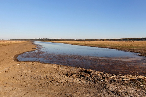
Picture: Map 1-19: ‘Magdolna-ér’ channel transformation into natural watercourse (before elimination)

Picture: Map 1-20: ‘Magdolna-ér’ channel transformation into natural watercourse (after elimination)